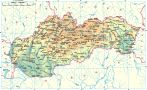
Tornaľa is situated in the region of Gemer, in the eastern part of the Rimavská Basin (Rimavská kotlina) which is divided by the river Slaná.
Findings from the Otoman culture which are dated to the Earlier Bronze Age and a burial ground from the Earlier and Later Bronze Age were found in the area. The first written reference of the town is from the year 1245, but it was inhabited already before that. In 1291 it belonged to the Tornallyay family.
In past Tornaľa was divided into two parts - Nižná and Vyšná, but both settlements later joined together. In the second half of the 16-th century the town declined when the local population tried to escape from the Turkish invasion. Development of the town was restarted after the railway was built and the town became a center of trade and administration.
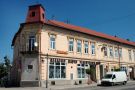
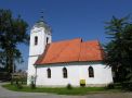
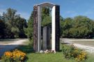
In the town there are classicistic curies from the 1-st half of the 19-th century, an early-gothic church from the 13-th century and a gothic church from the 15-th century (rebuilt in the 17-18-th century) with a painted wooden ceiling from the year 1768.
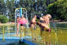
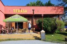
The most interesting attraction for tourists is a beach swimming pool situated in the city quarter Králik.